Can Feng Shui Start with a Map? Jidi Explore Brings "Dragon-Hunting and Acupoint-Finding" into Digital Life
When house-hunting, besides checking the MRT and daily conveniences, you can also zoom the map out and look at the mountains behind and the water in front. Jidi Explore uses public terrain data to analyze mountain-and-water configurations, turning traditional feng shui interpretation into queryable map information.
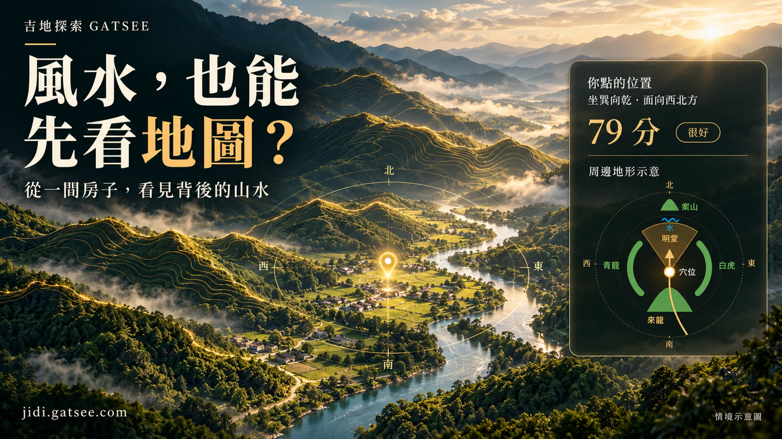
The cover is an AI-generated conceptual illustration. The article includes actual search and map screenshots and screenshots of the platform’s public sample report. Public locations are used for the walkthrough; rankings and scores reflect that particular calculation.
When house-hunting, we're used to opening a map to check the MRT, find schools, and calculate commute times. But if you zoom the map out a bit further, could the mountain behind the house, the terrain on either side, and the river flowing in front also hold clues worth noticing?
"Jidi Explore," under GATSEE (吉時到), extends its gaze from streets and house numbers out into the mountains and waters, combining public terrain data with traditional feng shui interpretation. This gives an additional online entry point to "dragon-hunting and acupoint-finding" (尋龍點穴)—something that previously required spreading out maps and visiting mountain sites step by step to understand.
Search First, Then View the Map: The Actual Process of Finding Auspicious Sites from Place Names
The map is the entry point for exploration. The following demonstrates the search and map operations after logging in, using Taipei's "Jiantan Mountain" as an example: first locate the place, then calculate nearby candidate positions, and finally click the bead markers to see the reasons. This set of screenshots uses actual search results from this session; the 79-point report that follows is a separate fixed public example provided by the official website.
Step One | Enter a Place Name, Select the Correct Location from the Candidate List
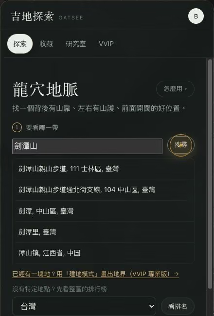
Enter "Jiantan Mountain" in the "Where do you want to look" field on the left, then press "Search," and the system will first list candidate place names. This time, "Jiantan Mountain Hiking Trail, Shilin District 111, Taiwan" was selected; once selected, the map will move to the corresponding location and place a red pin marker. When encountering places with the same name, first verify the administrative district and country to avoid finding the wrong location.
The search field indicates that you can use place names, addresses, coordinates, Google Maps, or supported property links; this screenshot demonstration uses place name search.
Enter the place name, press search, then select the correct location from the list; here, Jiantan Mountain Hiking Trail in Shilin District, Taipei was selected. Screenshot from the actual Auspicious Land Explorer interface, captured on October 18, 2026.
Step Two | Select the Purpose, Click "Find Good Locations in This Area"
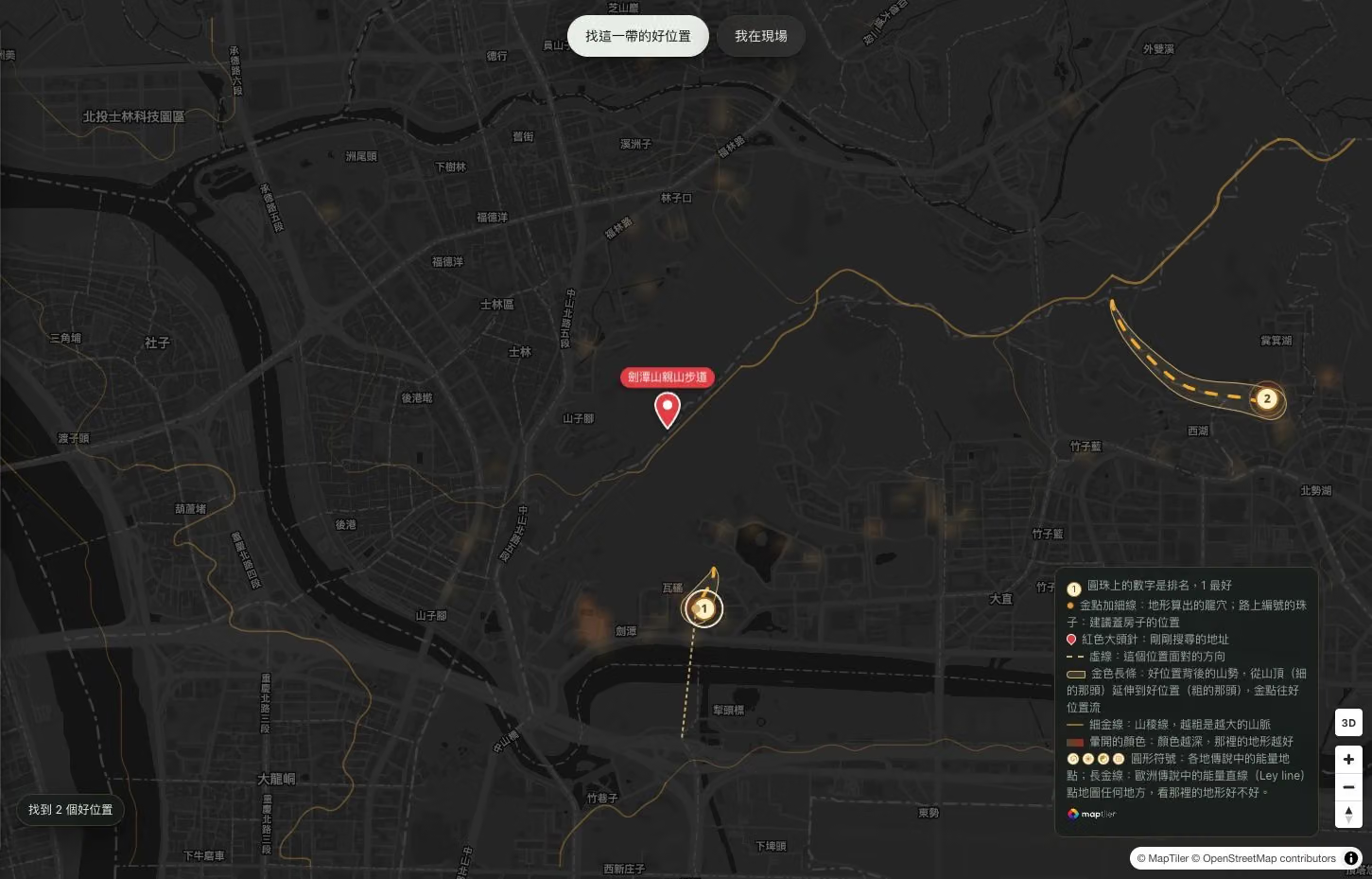
This time, the purpose "Residential Feng Shui - Gate and Path Inspection" was retained, then "Find Good Locations in This Area" was clicked, which starts calculating auspicious site candidates for the current map range. The interface also offers "Office/Storefront" and "Yin House (Burial Site) Landscape Viewing" options, which should be selected according to your own purpose. The red location pin from the place name search and the ranking bead markers that appear after calculation are two different types of markers.
The flat map simultaneously displays the search location and calculation results; this time the range found two candidate locations, with the 1 and 2 on the beads being rankings, not scores. Screenshot from the actual Auspicious Land Explorer interface, captured on October 18, 2026.
How to read the map:
Red pin marker: The location just searched.
Numbered beads: Rankings of candidate locations, with 1 representing the top result in this search; scores must be viewed by clicking on the card. The interface also marks suggested building positions with numbered beads on roads.
Thin gold lines and gold bars: Thin gold lines indicate mountain ridgelines; the more prominent gold bars show the mountain formation extending behind the candidate location.
Dashed lines: The direction the location faces.
Blurred heat zone colors: Based on the platform's rules, these represent terrain conditions, with darker colors indicating better terrain ratings at that location; layers such as dragon veins and heat zones can be toggled on the left side.
Step Three | Click "3D" to Raise the Mountain Terrain
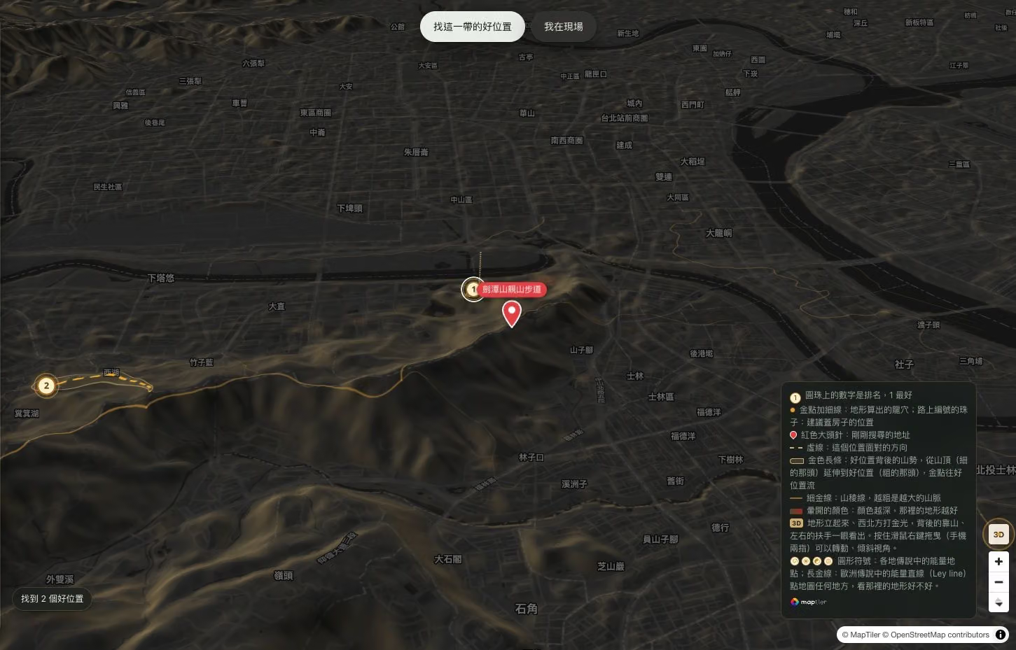
The "3D" button in the bottom right corner switches to a three-dimensional terrain view. After the map transitions from flat to a perspective with elevation variations, it becomes easier to directly compare how the mountain ridge extends and the surrounding mountain formations enclosing the site. According to the interface instructions, desktop users can hold down the right mouse button and drag, while mobile users can use two fingers to rotate or tilt the view.
The three-dimensional terrain makes it easier to identify the relative relationship between mountain formations and sites, while retaining the search location pin, ranking beads, and dragon vein lines. Screenshot from the actual Auspicious Land Explorer interface, captured on October 18, 2026.
Step Four | Click on a Bead, First Read the Result Card, Then View the Full Analysis
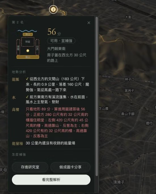
Clicking on a bead on the map will pop up an analysis card for that location. This time, the 2nd-ranked bead was clicked, and the card displayed a score of 56, along with the orientation, relative position to the road, incoming dragon vein, water systems, and the impact of surrounding tall buildings on the overall configuration. The card separately explains terrain and building conditions, allowing readers to first see the reasons before clicking "View Full Analysis" to read further.
Rankings and scores are results based on the specific range, purpose, and data conditions of that particular search; the bead numbers should not be taken as a fixed nationwide ranking, nor should they be directly used to infer whether land can be built on or used.
Bead number 2 corresponds to 2nd place, with the card additionally listing a score of 56 and the reasons; the "View Full Analysis" button below opens the detailed report. Screenshot from the actual Auspicious Land Explorer interface, captured on October 18, 2026.
A Backing Behind, Protection on Both Sides—First, Picture a Chair
The platform uses a chair to explain the "dragon lair" (龍穴) concept in feng shui: the mountain behind is like the chair's back, the mountain ranges on either side are like armrests, and the front retains open space. This everyday analogy gives terms like "backing mountain" (靠山), "Green Dragon" (青龍), "White Tiger" (白虎), and "bright hall" (明堂) an easy-to-imagine outline.
Opening the public sample on the official website, a location north of the Grand Hotel, near Jiantan Mountain, receives a score of 79 from the platform's algorithm. Clicking into the full analysis, the screen uses a terrain-direction diagram to mark the backing mountain, the mountain ranges on both sides, the water system in front, and the direction the "dragon" (incoming mountain range) comes from, explaining the scoring basis item by item. What was once an abstract mountain-and-water configuration becomes a chart that can be compared against and read step by step.
Four Actual Screens: Understanding How Auspicious Land Explorer Reads Mountains and Water
The following demonstration uses the fixed example of the area north of the Grand Hotel and around Jiantan Mountain, publicly available on the official website. On the introduction page, click "View the Full Analysis of the Example" to switch content via the section buttons at the top of the report; to analyze your own location, you must log in and use it according to your membership plan.
Feature One: First Identify the Dragon's Lair, Then Check Whether It's Embraced by Mountains and Water
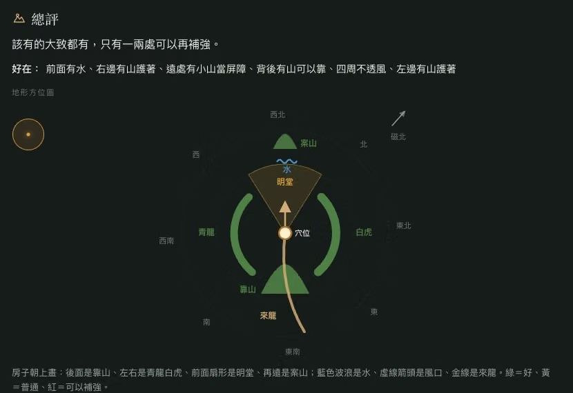
Open "Overall Assessment" and first find the "acupoint" marked in the center of the diagram, then look at the mountain behind it, the Azure Dragon and White Tiger on the left and right, and the bright hall, facing mountain, and water in front. The gold line represents the incoming dragon (mountain range), with the arrow pointing forward; the green, yellow, and red colors on the diagram correspond to the platform's assessment of good, average, and improvable items. Matching each position to the diagram makes it easier to understand the land's configuration than simply remembering an overall score.
Key reading point: Looking outward from the central acupoint, identify the backing mountain behind, the mountain formations on either side, and the open space in front. Image is an actual screenshot of a publicly available example from the Auspicious Land Explorer official website, captured on October 18, 2026.
Feature Two: Follow the Dragon Vein Cross-Section to See How the Mountain Range Connects to the Acupoint
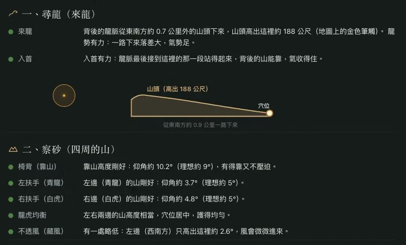
Switch to "I. Searching for the Dragon (Incoming Dragon)," and the report will explain in text and cross-section lines which direction the mountain range behind extends from, and the elevation relationship between the peak and the acupoint. Below, "Examining the Sand" separately lists the backing mountain, mountain formations on left and right, balance, and wind gap assessment, turning "having mountain support" from a single description into item-by-item information you can check against.
Key reading point: The dot on the right end of the cross-section is the acupoint; the lines in the front section show the elevation changes of the incoming dragon; below, the surrounding mountain formations are explained item by item. Image is an actual screenshot of a publicly available example from the Auspicious Land Explorer official website, captured on October 18, 2026.
Feature Three: Check Winter Solstice Sunlight, and Which Directions Are Blocked by Mountains
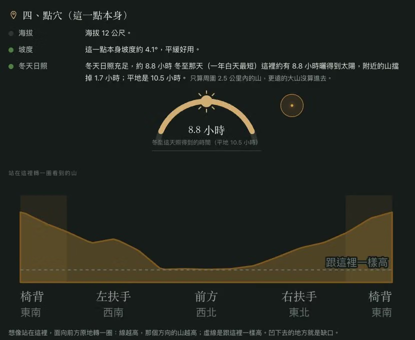
Click on "IV. Pinpointing the Acupoint (This Point Itself)" to view elevation, slope, and winter solstice sunlight. This public example estimates approximately 8.8 hours of sunlight at the winter solstice, with the panoramic terrain line below showing the relative height of mountains in each direction — a dip represents a lower gap. The sunlight estimate only takes into account mountain terrain within a 2.5 km radius and cannot be directly taken as indoor lighting hours; it still needs to be checked against the building and on-site conditions.
Key reading point: The curved line above shows the sunlight estimate, while the terrain line below compares the backing mountain, mountain formations on either side, and the height in front. Image is an actual screenshot of a publicly available example from the Auspicious Land Explorer official website, captured on October 18, 2026.
Feature Four: Distinguish Magnetic North from Map True North, Then Read the Facing Direction and Flying Star Chart
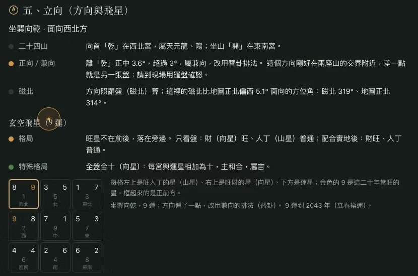
In "V. Establishing the Facing Direction (Direction and Flying Stars)," you can compare the sitting/facing direction, the twenty-four mountains, whether it is a proper or supplementary direction, and the difference between magnetic north and map true north. The example also presents a nine-palace flying star chart: in each grid, the upper left is the mountain star, the upper right is the facing star, and below is the period star. This part is interpreted according to traditional feng shui rules, and the direction still needs to be confirmed on-site with a compass; it is not an empirically proven prediction of fortune outcomes.
Key reading point: First check the direction data, then look at the nine-palace chart; the numbers in the diagram are arranged according to the traditional feng shui rules adopted by the platform. Image is an actual screenshot of a publicly available example from the Auspicious Land Explorer official website, captured on October 18, 2026.
This analysis examines the terrain from sixteen directions around the target location, observing whether there is a mountain behind, whether both sides form an embrace, whether the front is gentle and open, and whether there is natural water flow nearby. It then scores separately depending on the use—residence, storefront, or gravesite. For those comparing properties, beyond floor plans and interior photos, this offers another layer for viewing the relationship between a house and its surrounding landscape.
Paste a Property Link to Bring Online Observation to the Site
The way it's used is close to everyday house-hunting habits. You can enter a place name, address, or paste a Google Maps link or a link from a supported real estate website to search for the target location. Once on site, you can also use GPS and compass mode to match your current location and direction. This forms a connected flow from initial exploration on screen to actual observation while standing on the land.
Besides mountain formations and water systems, Jidi Explore also integrates winter solstice sunlight, facing direction, as well as Xuan Kong Flying Star (玄空飛星) and traditional ground-breaking direction items. The professional version additionally offers a building-lot mode, letting users draw the boundaries of a plot of land to view analysis suggestions for building position, orientation, and main door placement. Those who want to learn about the service first can also browse the introduction and samples for free before deciding whether to use the membership features.
The platform states that these scores are calculated based on public terrain data, reflecting the degree to which the terrain matches traditional feng shui conditions; they have not yet been individually verified on-site by a feng shui master. Land ownership, whether building is permitted, and on-site conditions must also be confirmed separately.
From seeing a house to understanding the mountains and waters behind it, what Jidi Explore offers is a way to slow down and re-observe the environment. Next time you open a map to look for a house, besides checking daily conveniences, you might also pull your view back further—to see where the mountains come from, and where the water flows to.
Feature introductions and public samples can be found at the Jidi Explore official website. Service details and membership plans are subject to official website announcements.